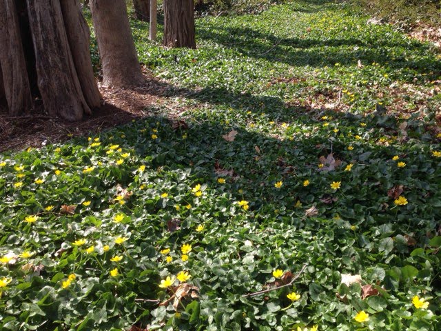
When lesser celandine (Ranunculus ficaria) came up in a shady moist part of my yard, I admit, I did not promptly rip it out, though I do know it is a confirmed Invasive Plant Species, on the official Connecticut List. I realized that this patch probably originated from a bulblet that I had tracked back from the floodplain after field work, likely stuck in a boot tread.
Its glossy, yellow petals were like those of a buttercup or marsh marigold, only there were more of them (eight versus five). The dark-green, scalloped leaves were shiny and heart-shaped, and formed a full, weed-free ground-cover, though spreading far less than the patches I had seen on the Quinnipiac River and Wharton Brook floodplains. I rationalized that this species was invasive in wetlands, not upland yards, so… I might as well let it grow and study it. When seed set failed altogether, I was reassured that seeds could not disperse to the Ten Mile River floodplain, only half a mile away. As a spring ephemeral, the lesser celandine dwindled as the tree canopy expanded, and by August I saw only a few yellowed leaves- and many bulblets. I erected a barrier of logs and brush so no one would walk there and pick up bulblets in their shoes.
Ranunculus ficaria spreads aggressively by bulblets in river floodplains, where floodwaters move the buoyant bulbs around, but I had rationalized that my patch was innocuous as a small sterile clone in an inland, upland setting. Two years later, my friend Jeanne Chesanow showed me a similar, small sterile patch of lesser celandine in her yard, also in shaded, mesic upland soil. She lives about a mile south of my house. I started to wonder, just how far do bees fly?
Lesser Celandine is reported to produce fertile seed erratically. Seeds may not have not formed in my and Jeanne’s clones because the female flowers must receive pollen from a genetically different mating type, and none grow nearby. However, with cross pollination between lesser celandine patches in multiple gardens, how soon will a threshold of abundance be reached, such that lesser celandine starts setting more viable seed? If that happens, will this plant “take off” in mesic, upland habitats, as well as river floodplains? Purple loosestrife spent many decades in the twentieth century, as a well behaved garden plant, producing few fertile seeds…. until that abundance threshold was reached and self incompatibility was no longer limiting. Only then did it start proliferating in a wide range of wetland and moist habitats.
This is a particularly tempting invasive, the more so because it forms a natural, attractive ground cover, and is hardy and carefree. It is widely sold! Most gardeners are probably unaware they are harboring an invasive species, may think it is Marsh Marigold (Caltha palustris). I wondered, just how many other yards in Cheshire also have celandine patches. It was time to stop playing around. I dumped a thick layer of mulch over my patch, and Jeanne got rid of hers as well. Digging it is risky, as bulblets are dispersed.
A year has passed, and it is early spring, mud season. My garden has no yellow celandine flowers. As a weekly erosion inspector at a school construction site, I am trying to persuade the contractor to spread hay over the idle bare soil, to reduce the export of fine sediment and phosphorus to the Quinnipiac River. I wonder, could the yellow-dotted carpets of Celandine over bare, floodplain soils actually benefit the river and Long Island Sound, by reducing phosphorus loading to during the early spring season? However, especially in moist floodplain habitats, large mats of lesser celandine obliterate other delicate spring ephemeral wild- flowers like trout lily, wild ginger, and spring beauty, and also compete with perennial sedges and spring-germinating annuals.
However, lesser celandine is reported to be much less less invasive in uplands than floodplains. Could this plant be useful as a spring ground cover for landscaping, in well-drained soils, until other garden perennials have reached summer biomass? Could it help reduce lawn areas and turf chemical use, to protect downstream water quality? More funding is needed for applied research, to more precisely understand which habitats are most vulnerable to a given invasive species, and also to study breeding systems. Is increased production of fertile Lesser Celandine seed really a threat?
Ebony spleenwort, characteristic of rocky ridgetop critical habitats, regardless of the type of bedrock.
I am often asked, just what is a critical habitat, and is it protected or not? My answer is drawn from a hybrid DEEP document (map plus explanations and keys) called “Critical Habitats” last revised in 2011. Recently retired DEEP plant ecologist, Kenneth Metzler wrote: “these habitat types have a long history of conservation interest and have been documented and studied as being among the most rare, unique, and threatened, habitats in the state.” Critical habitats support uncommon ecological communities, because their geology, soils, and/or hydrology are distinctive, which also confers scientific, educational and heritage value. They each support a characteristic and unique suite of plant and animal species. 25 upland critical habitats were identified in the Connecticut Comprehensive Wildlife Conservation Strategy (CWCS). The intent of the DEEP document is to help towns with their conservation planning – not to ban development of all critical habitats, but as a planning tool, to prioritize open space protection initiatives, in conjunction with other conservation planning principles: minimize habitat fragmentation, and maximize the size and ecological integrity of protected tracts. www.cteco.uconn.edu is the URL.
State statute does include protections for endangered and threatened species. Critical habitats are a good deal more likely than the average field or woodlot to include state-listed species (Endangered, Threatened, and Species of Special Concern.) Each critical habitat also has many other unusual plants and animals that don’t quite “make the cut” for Connecticut’s List – pitcher plant in a Black Spruce Bog, for example.
Also expected in a critical habitat are rare species among the understudied life forms like lichens, mosses, and soil microbes. These life forms are simply missing from the Connecticut Natural Diversity Database (NDDB) lists.
Potential rare species are likely to be missed by a targeted search for one or two species, especially because they are readily detected during a short window. Plant seeds may lie dormant in the seed bank, sprouting only in certain years. Many small plants are usually overlooked, even by botanists, except during a brief window when they are in bloom. Most insects, including butterflies and moths, are detectable only for a brief portion of the year. Rather than doing exhaustive, specialized searches, it is less expensive and simpler, to determine whether the expected suite of diverse, characteristic plant species is present, and if it is, to protect the critical habitat.
For example, we assessed a pristine black spruce/white cedar/ sphagnum bog recently, with hundreds of pitcher plants. The targeted listed species are insects that feed on pitcher plant; we are recommending conservation of the whole bog with a wide buffer, with no need for a search for the tiny rare insects.
A bog in Canterbury has 100’s of of pitcher plants, and land use boards fully understand that this critical habitat, and must be fully protected.; the biodiversity value of rocky outcrops is less widely understood.
Bedrock outcrop in Essex. A full inventory of the hilltop plant community is not possible outside the growing season. We recommended including the entire hilltop in the open space portion of the subdivision.
Planning Considerations
The “critical habitat” label is a flag for land use planners to commission a thorough inventory and to search for rare, state-listed species in multiple seasons, before the area is developed, and if possible over a several year period. Critical habitat status alerts planning boards that a property is likely to be a desirable, interesting destination for recreation, and a potential site for nature study and/or scientific investigations. Trails, towers, boardwalks, maps, and informative web sites can enhance these human values. Excessive human use may degrade them, but more often they are protected by human intervention, such as invasive plant control or occasional tree-trimming to maintain an open critical habitat. Public education on a critical habitat helps with its long term protection.
Some critical habitats, like black spruce bogs and white cedar swamps, are so unusual that their status is widely understood and accepted, and they also have the protection of being wetlands. The special status of other critical habitats is much less widely understood. As a botanist, I am most familiar with three largely overlooked critical habitats:
1) The group of plant communities on soils derived from traprock or limestone (subacidic/neutral and mineral-rich), including glades, dry forests, and summit shrublands; and
2) Outcroppings, ledges, cliffs, and rocky, open summits, with pockets of mineral-rich soil. These are defined as critical habitats in the ECO key, regardless of bedrock type.
3) The rich floodplains of larger rivers;
The status of these less well known critical habitats is not widely understood by regulators, natural resource professionals, and the general public; as explained above, official DEEP Critical Habitat status does not confer protection from development or quarrying, unless the areas are demonstrated to support Endangered or Threatened species. However, CTDEEP typically requires a survey for rare species by an expert, if a development site includes a known critical habitat. Floodplains are protected, but the main reason is avoidance of flood damage. Protection for privately owned rocky knolls and summits is still lacking in most town zoning regulations, despite official DEEP Critical Habitat status.
For the volcanic traprock ridges and certain ridges with amphibolite minerals, there exists already a model ridgeline protection ordinance, based on a CT Statute (Sections 8-1aa and 8-2 c), incorporated into the zoning regulations of some towns. This ordinance applies only to the more dramatic, high ridges, though low ridges, if reasonably undegraded by man, also include critical habitats with characteristic and unusual traprock geology, botany, and fauna.
Zoning regulations can also be amended to protect better natural features meeting certain criteria with value for the community as a whole: heritage value, outstanding aesthetics, or historic, scientific, and/or educational interest. Protection of these natural features can also be a goal guiding open space acquisition activities by municipalities, the state, and private land trusts. However, consistent with the Connecticut Comprehensive Wildlife Strategy, the long term welfare of the fauna and flora will better served by one sizable (e.g. over 100 acres) preserve with a few critical habitat pockets, than by multiple critical habitat pockets (rock outcrops) in a matrix of small woodlots and development.
History of the “Critical Habitat: Concept
DEEP has been refining its list of “Critical Habitats,” for many years, building off those identified by Joseph Dowhan and Bob Craig in Rare and Endangered Species of Connecticut and their Habitats (1976), with descriptions of all of the State’s Ecoregions (DEEP Natural Resources Center Report of Investigations No. 6.) My associate, George, and I have referred to this red book so much in our ecological consulting work, that both our copies are tattered.
For over a decade, natural resource professionals cited the List of 13 Imperiled Habitats developed by Ken Metzler of CTDEEP and David Wagner of the University of Connecticut at Storrs. It includes one difficult-to-map habitat: “headwaters springs and seeps” that is not on the current DEEP critical habitat map key, although it is a fragile habitat for multiple rare and uncommon species, and crucial for the health of larger streams and rivers. Better consistency is needed between the Imperiled Habitats List and the new CT ECO document.
The current CT ECO (Connecticut Environmental Conditions On-line) classification system includes a map showing the larger critical habitat units, and also a key with detailed definitions of each critical habitat. Since the scale of the map is such that most occurrences are omitted and since much of the state has not yet been surveyed, the introduction and the key are actually the most important parts of the document.
A fine introduction is Dr. Robert Craig’s book Great Day Trips to Connecticut Critical Habitats (2004), which is available, used, on line. This readable book is a guide to actual examples of fascinating critical habitats, accessible to the general pubic, with much thoughtful, scientific explanation. Foremost a bird expert, Bob Craig now runs Bird Conservation Research, Inc., a non-profit in Eastern Connecticut. I knew him twenty years ago in grad school at the University of Connecticut at Storrs.
Scale Considerations
The group of critical habitats associated with The Metacomet traprock ridges occupies a tiny fraction of the state of Connecticut, but is nevertheless extensive enough to support large metapopulations of both common and uncommon plants and animals. The river floodplain habitats are include unusually large critical habitats, ecologically and genetically linked by flowing water.
I keep encountering morphologically distinctive plant varieties in these critical habitats, and realize that genetic variability also encompasses unseen metabolic characteristics, that will help plants adapt to ecological change. A gene pool with hundreds or preferably thousands of individuals is needed for a good prognosis for long term survival in the face of climate change and other disturbances.
Horticultural and landscaping potential and even potential for medicinal use are other reasons to preserve the botanical biodiversity in critical habitats. For example, the smooth aster variety shown below (Symphiotrichum laevis) is bushy & colorful, and tolerates a dry, rocky site on West Peak of Meriden’s Hanging Hills. It is a lovely and ornamental perennial wildflower, and would be well suited to xeriscaping.
Impressive data for many traprock taxa has been collected as part of development applications, such as the gas plant application on Cathole Mountain in 1999. The Connecticut Botanical Society and the local bird clubs have long term data from many field trips to subacidic and rocky critical habitats.
Glade habitat on West Peak of the Hanging Hills, in Meriden, June 2011. The grassy “lawn” is Pennsylvania sedge, and the flower is smooth rock cress, the food for the caterpillar of the endangered orange falcate butterfly. Hop hornbean, a typical glade tree, of subacidic, mineral-rich soils, at left. A talus slope is in the background.
The complex of critical habitats on the Metacomet traprock ridges has large populations of characteristic species like ebony spleenwort, bottlebrush grass, dwarf saxifrage, and hop hornbeam. They are not Endangered or Threatened species, protected by state statute, but are still species that are scarce in the surrounding, fragmented suburban landscape. Other species like Eastern box turtle and Ribbon snake, are listed as Species of Special Concern, such that CTDEEP can require searches and management plans, but cannot prohibit habitat development. Similarly clusters of crystalline bedrock outcrops in several sizable forested tracts along the Connecticut coast (including “The Preserve” in Essex and Old Saybrook) also support robust populations of Special Concern reptiles, and metapopulations of uncommon, rocky-site plant species like smooth foxglove and orange-fruited horse gentian. Along river floodplains, flowing water and waterfowl disperse seeds and link small stands of rare and uncommon plants, like Davis’ sedge, into larger genetic metapopulations.
For some taxa, a critical habitat need not be large and continuous so long as other examples are within dispersal distances for seeds, pollen, moths, etc. Such a parcel of critical habitat is still part of the overall unit, from a genetic standpoint. The on-line CT ECO map includes the large, contiguous well-known examples of critical habitats. Many other smaller examples are also worthy of study and protection, if they have not been severely degraded by invasive species or past farming.
Critical Habitats that lie within a much larger matrix of natural habitat are especially valuable from an overall wildlife conservation standpoint, especially for forest birds, large mammals, and for vernal pool amphibians. Example are the summits of Connecticut’s northwest hills; the extensive rugged forests with many bedrock outcrops in the undeveloped parts of Essex and Old Saybrook; and Cathole Mountain; and the Silvio Conte wildlife Refuge along the Connecticut River. The lower forested slopes of traprock and limestone ridges are not critical habitats, but they greatly increase the width and size of the habitat blocks. They also help protect the critical habitats along the ridge lines from colonization by invasive plant species. For example, the large, latent Summerlin Trails residential project on Cathole Mountain, as initially conceived, would avoid the upper ridge crests and critical habitat areas, but would much reduce the size of the overall habitat block, with potential to harm vernal pool species and area-sensitive forest bird populations.
Potential Outreach
Ample interesting material is available for outreach on critical habitats. A newspaper article or radio program could use examples of success stories, like Hubbard Park in Meriden and Quinnipiac State Park along the floo0dplain of the Quinnipiac River; of dramatic battles, like that over development of a pristine section of Cathole Ridge off Kensington Road in Berlin and of Cedar Ridge in Newington with outcome still unclear; and of destruction like the mined section of Corporate Ridge in Rocky Hill. Media outreach could revisit the volcanic geologic history, and past dramas, like the story of the now-defunct gas powered plant on Cathole Mountain in Meriden. It could remind the public and the land use boards of the successful campaign, led by Norm Zimmer in the 1990’s, for a Ridge Protection Compact.
What is a drumlin anyway? A gremlin with an aptitude for percussion? Seriously, a rounded, elongated hill in the Connecticut landscape is probably a “drumlin”. The best known is Horsebarn Hill on the eastern side of the UConn campus at Storrs. Landing Hill in East Haddam was in the local limelight several years ago. Lately I’ve been working on Meetinghouse Hill and Misery Hill in Franklin. The Goshen Wildlife Management Area is another. The word “drumlin” comes from Ireland, where this land form also occurs.
The core of a drumlin hill is fine-textured, compact glacial debris, though bedrock may be underneath, poking through in a few places. The compact “hardpan” layer (in common parlance) may be over 100 feet thick, and dates from the prior Illinoisan glaciation (over 128,000 thousand years ago). Only the top layer, usually just a few feet deep, is sandier, looser soil, formed from the melting ice masses of the more recent Wisconsin glaciation, underlain by the compact till (scientists’ terminology).
These soils are seasonally wet. Though the level summits seem, at first glance, to be well-suited to community development, they are challenging to develop, whether on drumlins or elsewhere, such as plastered onto the sides of traprock ridges. Most gently sloping drumlin hilltops in New England used to be productive hayfields, growing lushly in spring when soil moisture was available, going dormant in mid summer. Pockets of wet meadow were rich in flowers, like New England Aster. Drumlin fields make fine hunting territories for raptors like barred owl.
Colorful wet meadow perched on top of drumlin.
Multiple seasonal seepage wetlands and headwaters streams flow down drumlin hillsides. They are a valuable source of clean water for the drainage basin if the drumlin is undeveloped, they but may become conduits for construction runoff.
There is more groundwater discharge on the nearly level sections of drumlin hillsides than on the steep sections. These are also prone to septic breakout.
Only a small percentage of Connecticut’s soils are compact tills but a disproportionate share of construction site fiascos and problem-plagued new subdivisions occur on hardpan soils. Wet, silty, sticky hardpan soils, on drumlins and also in other landscape settings, can become a mire for heavy construction equipment because the snowmelt and spring rains “perch” on top of the hardpan. Saturated silty soils are highly erosive, often an erosion control nightmare. Flooding problems are more severe than on absorbent soils, and water pollution from lawns and septic systems becomes a problem at lower home densities. Break-out from home septic systems happens more often.
Typical complaints of drumlin residents: wet and moldy basements, icy sidewalks; soggy, fungus-infested grass, burned-out grass, and dying shade trees; extended sump pump operation (not energy efficient), mosquitoes, and septic odors; and polluted down-gradient ponds. These all become more of an issue for seasonally wet, drumlin soils, because more water stays at the surface, as it cannot soak into dense hardpan soil. (Runoff coefficients are higher, in engineering jargon.)
With careful home and septic system placement, curtain drains, and appropriate landscaping, one can avoid some of these problems – but only if home densities are relatively low.
Ironically, the loose upper soil layer of a drumlin is usually so shallow that it holds little reserve water during dry spells, so drumlin lawns need much irrigation in summer, though excess water is the problem in other seasons. Solutions: small lawns, partially wooded yards, and/or a meadow landscape with drought-tolerant grasses like Little Blue Stem, a.k.a. Poverty Grass.
A Plea for Guidance
Could CTDEEP and our Conservation Districts provide land use boards, planners, and developers with more guidance on drumlins’ multiple constraints? On-line mapping (Web Soil Survey or WSS) available from the Natural Resource Conservation Service (NRCS) does show the approximate locations of seasonally wet, hardpan soil units, like the Paxton, Woodbridge, and Wethersfield soil series.
More guidance is needed to make sure fertilizers and pesticides are not applied before or after heavy rains. This happens all the time in Connecticut suburbs! Turf chemicals tend to run off drumlin soils, more than off more absorbent soil types, especially when the soils are already soggy.
Few understand that watercourse setbacks often need to be wider and septic system densities need to be lower on compact till soils, to protect down gradient wells, headwaters streams, pools, and lakes from excessive nitrogen, in nitrogen enriched groundwater and runoff. Because they reduce lot yields, these constraints need explanation in an official DEEP guidance document, preferably also in a CT Health Department memorandum!
Clear-cutting may seem to be more economical for the developer, who should be warned that this is not wise on a drumlin! To minimize future “water woes”, maximize remaining tree cover when subdivisions are built. The reason is two-fold: 1) to slow the velocity of the falling rain, and 2) because trees spew thousands of gallons of water into the air as water vapor (transpiration), helping dry out those surface soils. After clear-cutting, a drumlin hillside that used to be wet only in March and April may stay wet to the surface though June – and before long, one will see the tell-tale mottles and grayish matrix color of a jurisdictional Connecticut wetland soil.
Some, but not all engineers use underdrains and clay stops to prevent frost heave damage to roads and utility pipes, and to allow shallow groundwater to continue to seep down slope to wetlands that depend on this water source – instead of being shunted along roadbeds and sewer lines. Guidance is also needed in this area.
Once aware of drumlins’ constraints and resources, town zoning boards will be able to guide development more appropriately, protecting valuable vernal pools and hillside streams, and at least a portion of the productive forests. For expansive overgrown fields on flat-topped drumlins, if the alternatives of farmland or grassland wildlife habitat are not possible, at least the damage to down-gradient headwaters resources, from a low density, large-lot residential community, with small lawns, will be much less than from a large, dense subdivision.
Very High Toxin Concentrations found in Arctic Whales
The link below is an article sent by a colleague on the surprisingly high levels of toxins, found in arctic whales. Concentrations of toxic heavy metals like cadmium and chromium, were orders of magnitude higher than the danger levels for human fish consumption. At every step in the food chain, a persistent metal toxin (slowly- or non- biodegradable) bio-magnifies (tissue concentration becomes higher). Metals in road runoff that reach the ocean biomagnify in seafood. Abroad in many countries, DDT, which persists indefinitely, like metals, is also still used. Persistent toxins are also transported thousands of miles though the oceans, in currents- potentially the gulf stream- and by wind-driven surface flows, and also by migrating fish and whales. (This is similar to the insecticide bio-accumulation problem mentioned in my recent zigzag dogwalking post.)
Oil Toxins will not be contained in the Gulf
The take home message: not just the Gulf of Mexico and its coastal marshes are threatened by the Gulf Oil Spill, and that threat is not just in the distant future.
When walking my dog Mackie in our tidy, suburban neighborhood, I zigzag back and forth across the street, trying to avoid lawns that are aggressively chemical-treated, as Mackie is always “nose to the ground” unless he hears something of interest in the distance.
Mackie and I zig zag between sidewalks that border apparently safe lawns. I look for clover leaves, variably green color (not evenly dark green) , and small, low-growing patches of lawn wildflowers. This odd behavior is based on convincing anecdotes I have heard of repeated cases of the same cancer occurring among different dogs with similar exposures to pesticides. It is also based on my reading of the results of epidemiological studies, summarized in the informative publications of Nancy Alderman’s non-profit, Environment and Human Health, Inc. based in North Haven. Dogs are even more vulnerable to cancer than children, and we have already lost two family dogs to cancer: Tejana and Poka. Poka died at Age 11 of jaw cancer, and would have died at 10, without expensive surgery. Tejana lived to 15, but then during her first five years she was walked in urban vacant lots and on beaches, not in suburbia.
I began zig zag dogwalking after I heard several stories from the most dynamic trainer of organic landscapers in southern New England, Chip Osborne, out of Marlborough, Mass. He was the keynote speaker at an Ecological Landscaping conference in Springfield, a few years back. He told the class that he used to work in a greenhouse. His dog would lie under the potting table, with occasional drippings falling on them (with dissolved fertilizer, fungicide, etc.) The dog, and then its successor, died of the same cancer.
He told a second anecdote: a lady in a new residential community/cum golf course walked her dog on the lovely course every day. Her dog died of a nose cancer. She got a new dog, and walked the dog along the same route. Her new dog also got cancer, the same type – and she moved out. Of course dozens of fungicides, herbicides, and insecticides are applied to golf courses, so it is very hard to know, without a real epidemiological study. The story teller quit his propagation occupation and went on to start a successful organic lawn care business, and also teaches many training workshops for other landscapers, transitioning to this approach. He testifies for citizens groups as well.
The man believes in what he teaches; he knows that the organic approach to landscaping is not only better for the bees and other insects and wildife; it is safer for people and dogs.
As John Stuart Mill (1806 to 1873) said:
“One person with a belief is equal to a force of 99 who have only interests”
I heard Chip give an articulate presentation to a Westport land use board, explaining how one achieves sustainable affordable lawn care without chemical applications, refuting advocates of tire crumb athletic fields for children.
Besides the health of children and pets, lawn care practices can affect our water resources. My subdivision was built before the days of stormwater management. Whatever folks apply to their lawns (e.g., excess fertilizer and pesticides) may also wash over the curb along the pavement into the catchbasins, and thence into the River.
When walking the dog, we use a pooper-scooper or plastic bag, not just to avoid being verbally attacked by my neighbors, but also to keep the feces from being washed by the rain into the extensive system of catch basins, which dump directly into the streams in our neighborhood.
Not only does our neighborhood have fewer wildflowers, wild bees and beetles than it used to; the tributary streams fed by runoff (2 mg/l of nitrate last time I tested our stream ) are nearly devoid of life. The Ten Mile River, dowonstream also has fewer aquatic insects to feed trout , dace, suckers, and wood turtles.
Friends say: why don’t you just walk your dog in a park? Here in north Cheshire, we do have lovely open space behind us, The Ten Mile lowlands are great for hiking and free runs but only in the non-growing season, unless one is a bird watcher coated with bug spray. We can manage driving Mackie to a park maybe once a week, but not three times a day! Fortunately traffic levels are low in our neighborhood, except in late afternoon and early morning, so zig-zagging across the much-too-wide road is pretty safe.
It is a relief to visit Ships Hole Farm in Long Island, with no dog-walking constraints related to pesticide anxiety.
Violets and a dandelion- early spring lawn wildflowers at Ships Hole Farm.
As a scientist I do understand, that we are dealing with possible health risks, and that the majority of applied chemicals are likely not hazardous to humans. However, the other matter is that a sustainably managed lawn is a diverse and interesting mini-ecosystem, and can be lovely as well. It dos not harm fauna, like Northern Flickers , song sparrows, flower beetles, honeybees, and moles. …. more fun to walk past and look at- and probably safer- than a lawn that receives an intensive turf chemical regimen.
Bluet is a lovely lawn wildflower, with grasslike leavesNaturalized white violets, an attractive, even low groundcover
Flowering bushes buzzing with bumblebees may also indicate a safe lawn. Sadly, it is years since I have seen a honeybee in my Cheshire neighborhood and the miniature solitary bees have also become very scarce. However, I still do find honeybees on vacant lots (just yesterday on Broad Street in downtown Manchester) and in poorer neighborhoods. On those properties there is probably little use of expensive, beetle grub insecticides (imidocloprid is a neurotoxin that also harms a great many other insects, including bees.)

 However, especially in moist floodplain habitats, large mats of lesser celandine obliterate other delicate spring ephemeral wild- flowers like trout lily, wild ginger, and spring beauty, and also compete with perennial sedges and spring-germinating annuals.